Introduction
On November 10, 2023, Kristín Jónsdóttir, head of the Icelandic Meteorological Office’s department of volcano research, was having a rare day off. “It was my 50th birthday,” she said. Then everything began to shake. She would spend the day staring at her phone, watching the earthquakes bloom across maps of Iceland’s Reykjanes Peninsula.
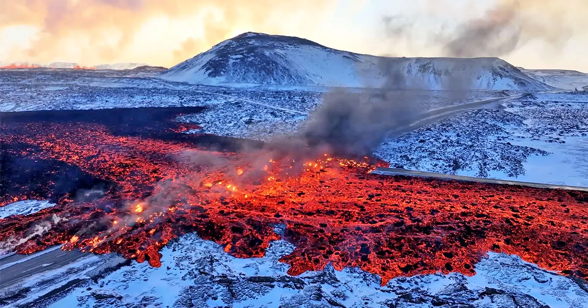
The peninsula experiences fissure eruptions, where the ground splits open and lava pours out. Since late October, attention had been focused on the peninsula’s Svartsengi region — home to the popular Blue Lagoon spa, a geothermal power plant, and the coastal town of Grindavík. The peninsula’s last three fissure eruptions had flooded isolated valleys with fire. Now, though, the town was under threat.
The maelstrom of temblors on November 10 revealed that a buried magmatic river had snaked its way toward Grindavík and its 3,600 inhabitants. More distressingly, a dike — a vertical magma body akin to a curtain of liquid fire — had fountained up from that subterranean river, stopping just shy of the surface.
Quickly, the authorities evacuated the town. And then everyone waited.
On December 18, a volcanic fissure cleaved the ground to the town’s northeast and painted the wintry soil with molten rock. The intense eruption lasted a few days and stayed outside Grindavík.
Then at 3 a.m. on January 14, the few residents who had returned to their homes were awakened by klaxons and text messages telling them to flee. Another eruption had invaded the town. By the time it ended 60 or so hours later, several houses had been engulfed, but no one had died.
Grindavík’s residents owe their lives to proactive local authorities, emergency managers, and the study of Earth’s interior. Scientists had been tracking the movement of magma by decoding seismic waves and distortions in the planet’s crust. By mapping the peninsula’s volcanic plumbing, they’re building a better understanding of how volcanism works in general, while also aiming to provide even more precise local forecasts in the future.
Introduction
Work is ongoing; this volcanic crisis is far from over. A peninsula that hadn’t seen an eruption for 800 years has now woken up, and geologic evidence suggests that eruptions could continue for years, decades or even centuries.
“We’ve only seen a fraction of the lava come up,” Jónsdóttir said. “Nature is grim.”
The Power of Geophysics
Fissure eruptions — which also occur elsewhere in Iceland, as well as in Hawai‘i and (several millennia ago) Idaho, New Mexico and California — are hard to forecast. In contrast to classic volcanic eruptions featuring a mountainous landform, it’s tough to predict exactly where the fissures will materialize.
The Reykjanes Peninsula’s fissure volcanism is especially peculiar. Ancient lava flows, now frozen in place, reveal that eruptions have afflicted the region for many years at a time, but that on either side of these episodes, volcanic activity was absent for centuries. The last period of eruptions ended in 1240, and that was the third of its kind on the peninsula over the past 4,000 years, with each cluster separated by roughly eight centuries. But why does this roughly 800-year periodicity exist? “We still don’t know, to be honest,” said Alberto Caracciolo, a geologist at the University of Iceland.
That there’s volcanism at all isn’t shocking. The peninsula sits atop a mantle plume — a fountain of heat rising from Earth’s core-mantle boundary. And it straddles the Mid-Atlantic Ridge, an eruption-prone suture between the Eurasian and North American plates. Reykjanes’ tectonic restlessness has made the area one of the most scrutinized volcanic regions in the world.
So, in 2020, when tens of thousands of quakes started rocking the peninsula and the ground began swelling, scientists suspected that the commotion might be a prelude to a volcanic performance eight centuries in the making. They only had to figure out where.
Hunting Magma
When magma breaks rock deep in Earth’s crust, it creates earthquakes with distinct signatures. These seismic waves and their properties furnish scientists with the most immediate — and least ambiguous — clues about the presence and migration of magma. During a volcanic crisis, “if you could only have one thing,” said Sam Mitchell, a volcanologist at the University of Bristol, “it would be that.”
Magma on the move, if it’s shallow enough, also noticeably deforms the ground. Satellites use radar to identify changes in elevation over the course of hours, days or weeks. Ground-based GPS stations also provide high-resolution, real-time information about elevation changes.
Jónsdóttir suspects that the cacophony of quakes that began in 2020 was due to both magmatic migration and the movement of tectonic plates. In Iceland, the Eurasian and North American plates are not cleanly separating but are scraping against one another as they shift. Between eruptive cycles, plenty of tectonic stress builds up. Then, when magma worms its way into subterranean crevasses along this boundary, it triggers the release of that tension in the form of potent and frequent quakes.
Introduction
In early 2021, though, this magmatic machine switched gears. Both elevation changes and seismic commotion suggested that magma was gathering below Fagradalsfjall, a small volcanic mound next to an uninhabited valley. For many months, long-period quakes had shivered within the peninsula’s deep crust. These types of earthquakes “have been seen beneath other volcanoes all around the world, and are still not fully understood,” said Tom Winder, a volcano seismologist at the University of Iceland. Though enigmatic, they suggest that something slow is happening — the gradual fragmenting of hot rock, perhaps, or magma blobs squeezing through a constriction.
Then, on March 19, 2021, the peninsula erupted for the first time in eight centuries. For six months, molten matter fountained from a fissure next to Fagradalsfjall. Two shorter eruptions followed, in the summers of 2022 and 2023.
Aside from those bass-like long-period trembles, the overall seismic symphony that preceded the three Fagradalsfjall outbursts suggested that magma was taking an unusual route to the surface. Instead of gathering in the shallow crust, molten rock appeared to be rocketing straight to the surface from a great depth — the boundary between the crust and the underlying, puttylike mantle. “It’s pretty unheard of,” Winder said.
Compared to many Icelandic volcanic systems, Fagradalsfjall was acting strangely, but at least it was happening far from anyone or anything.
It wasn’t until October 2023 that scientists’ curiosity turned to anxiety when activity shifted to the infrastructure-laden Svartsengi region to the south.
The Battle of Grindavík
The ground in the Svartsengi region had risen, then stopped rising, several times since 2020, implying magma was arriving at irregular intervals, although without erupting. But toward the end of 2023, the pace of movement spiked. Magma was entering the region faster than ever. By mid-November, a sill — a horizontal body of magma — of elephantine proportions was sitting just a few kilometers below Svartsengi. “Everybody was on their toes, and we didn’t really know what would happen next,” Jónsdóttir said. It wasn’t clear where or when an eruption might take place.
Introduction
The quakes that rocked the region in November helped point the way. Initially, their sheer number overloaded the Icelandic Meteorological Office’s seismic monitoring capabilities, but staff quickly managed to find the chorus in the chaos and decipher its lyrics: Rock-breaking quakes meant that some magma had left the sill and moved sideways. And ground-monitoring satellites confirmed what the seismicity suggested: The ground above Svartsengi’s sill had fallen as magma drained.
It was easy to see where that magma had gone. The ground around Grindavík was sinking. To a volcanologist reading the land, that pattern revealed not an absence of magma, but an incursion of it. The magma that left the sill had moved sideways before shimmying upward directly below Grindavík. As it rose, this vertical tendril of magma pushed the walls of rock to its sides out of the way. That, in turn, caused the land above the tendril to slump into the newly created void. Later, scientists would report that at one point during the November 10 quake storm, some 7,400 cubic meters of magma was surging from the sill into the tendril every second.
Signs of this subterranean shuffling were also spotted inside the geothermal power plant’s boreholes. Volcanic gases, like sulfur dioxide, escape from magma at shallow depths and may signal an impending eruption. Scientists saw that gas, and a change in pressure, within the boreholes — another indication that magma was on the move toward town.
A colossal tendril of magma, known as a dike, had sprouted beneath Grindavík, with a crest just 800 meters below its streets.
Within hours of the November 10 quake storm, scientists identified a 10-mile-long section of land where an eruption seemed highly likely. It sliced through Grindavík from a string of old volcanic craters northeast of the town to its southwest. By midnight, Iceland’s Civil Protection had evacuated the town, and construction workers hurriedly built protective walls in the areas most likely to be flooded by lava.
Introduction
Over the next few weeks, geophysical observations revealed that magma was still flowing into the region. By December 18, based on the ballooning ground, scientists calculated that about 11 million cubic meters of fresh magma had accumulated in the sill. That appeared to be about as much as it could hold. That day, another noisy flow of magma left the sill and overfilled the dike. Rock-breaking quakes warned scientists that magma was finally making a break for the surface, and 90 minutes after those quakes began, “we had the eruption,” Jónsdóttir said. “That was a really fast event.” Over the next few days, the eruption drained the dike enough for it to stabilize and settle.
That pattern repeated before the January 14 eruption: 12 million cubic meters of magma stuffed the sill before triggering an eruption four hours later. This time, infernal matter oozed out of a 3,000-foot-long crack that emerged near one of the protective walls to the town’s north, which managed to deflect the lava. But a second, smaller fissure appeared right at the town’s edge, behind the wall, and destroyed three houses.
Afterward, the sill started inflating again. By this point, scientists had calculated that an eruption would become highly likely when the sill filled with at least 9 million cubic meters of molten matter. By early February, the sill had exceeded that threshold, and on February 8, another eruption began. A 3-kilometer-long fissure opened near the site of the December eruption, funneling lava away from Grindavík but toward a pipe that supplies hot water to much of the peninsula.
And so the cycle continues.
Introduction
Geochemical Revelations
The geophysical techniques scientists are using to take the pulse of Svartsengi’s magmatic heart aren’t just tracking the hazard in real time. They’re also helping to construct a picture of the arteries that funnel all that magma to the surface — which is crucial for understanding the entire peninsula and how it might behave on longer time frames.
Fagradalsfjall and Svartsengi — the two currently active volcanic systems — are separated by just a few miles. Despite their proximity, geologic evidence strongly suggests that they are distinct systems. Their subterranean architectures are manifestly different. At Fagradalsfjall, magma rushes from the mantle straight to the surface, while at Svartsengi, it’s temporarily stored in the shallow crust.
And yet, puzzlingly, the two systems seem to draw material from the same source in Earth’s mantle, suggesting a deep connection.
Ed Marshall, a geochemist at the University of Iceland, has studied freshly scooped lava from eruptions at both sites to try to determine how the two volcanic systems are connected and why they’ve been taking turns erupting. “You want to park in a place where the gas and lava aren’t going to take you out,” he said. Then “you walk in, you scoop the sample, and you get the heck out.”
In general, Icelandic lavas display similar chemical patterns. But “Fagradalsfjall has the world’s weirdest melt chemistry,” Marshall said, referring to the specific mixture of elements and compounds that make up its magmatic soup. “It’s actually not just weird. It’s unique.” Unique, that is, except that the Svartsengi lava has almost exactly the same chemical fingerprints, even though Fagradalsfjall and Svartsengi are seemingly independent volcanic systems. “That makes absolutely no sense,” Marshall said. “Nature’s just messing with us at this point.”
But “if things are physically connected at depth,” he said, “that’s a pretty elegant solution to the whole problem.”
Seismic analysis of the peninsula’s volcanism is ongoing. Scientists hope to be able to forecast where it will emerge next in the coming months and years, as they did with the recent eruptions. As a start, Halldór Geirsson, a geophysicist at the University of Iceland, and his colleagues are using satellite radar to map faults and fractures on the peninsula during this period of unrest, which they suggest can reveal hidden faults, including those that may be the sites of future fissure eruptions.
There’s no guarantee that subsequent eruptions will follow the same pattern as Svartsengi’s recent outbursts — the sill-dike heart of the system is not necessarily a fixed feature. “Every time you have an eruption, you change the plumbing system. It doesn’t reset back to zero,” Mitchell said.
Grindavík’s future habitability is an open question, and it remains to be seen whether the peninsula’s other towns will be confronted with torrents of lava. Reykjanes Peninsula’s new hypervolcanic era has just begun, and it could last years, decades, perhaps even centuries.
“Unfortunately, there’s no good news ahead,” Jónsdóttir said.
- SEO Powered Content & PR Distribution. Get Amplified Today.
- PlatoData.Network Vertical Generative Ai. Empower Yourself. Access Here.
- PlatoAiStream. Web3 Intelligence. Knowledge Amplified. Access Here.
- PlatoESG. Carbon, CleanTech, Energy, Environment, Solar, Waste Management. Access Here.
- PlatoHealth. Biotech and Clinical Trials Intelligence. Access Here.
- Source: https://www.quantamagazine.org/inside-scientists-life-saving-prediction-of-the-iceland-eruption-20240220/

