Introduction
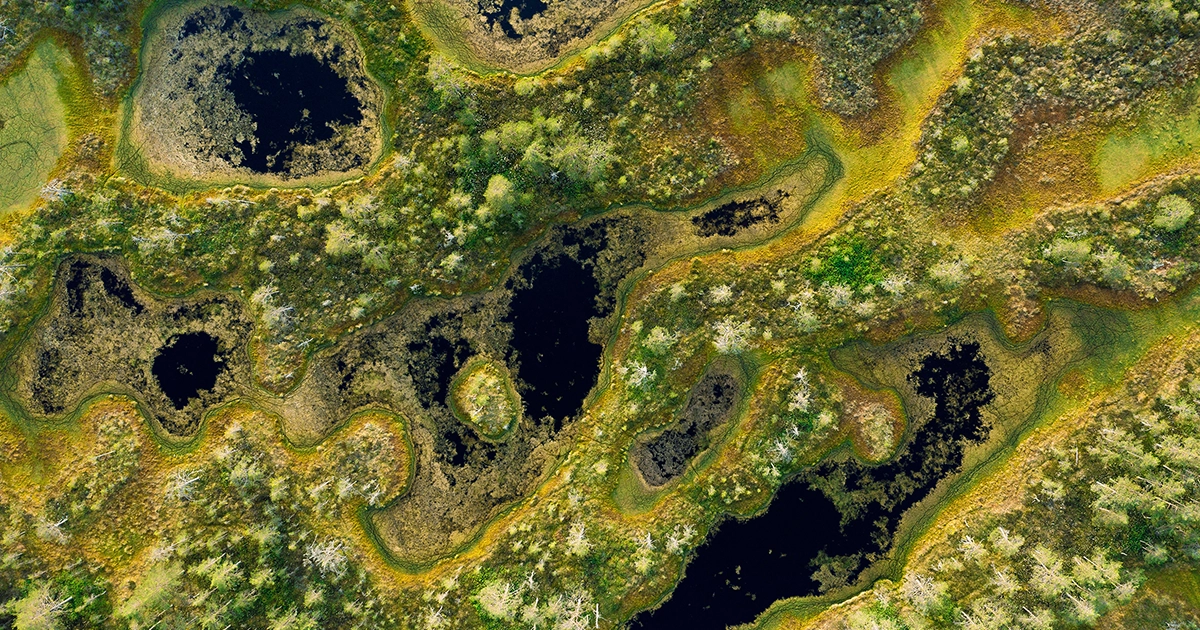
A visit to a peat bog will make you rethink everything you know about the surface of our planet. A bog is land, sort of, but not in the solid-ground sense you’re used to. If you try walking across one’s surface, you may feel the soft organic muck known as peat undulate beneath you — or you may sink into it yourself. From the surface, it’s hard to know whether the waterlogged peat extends 3 feet deep or 30.
These strange, soggy places have historically been reviled, and many have been drained so that people could build on or farm the land. In the era of climate change, however, they are gaining newfound fame: Peatlands are among nature’s most effective ways of storing carbon and keeping it out of the atmosphere. To ensure it remains there, scientists have long sought a way to calculate how much peat and carbon they store.
A recent study may provide the answer. Late last year in Nature, scientists reported a mathematical model that they say can calculate the shape of any peat bog on Earth using a simple set of measurements. The model, if it works as advertised, could make it easy to tally up the carbon in a bog — a crucial step in determining a given bog’s contribution to reducing climate change.
Shawn Lum, an ecologist at Nanyang Technological University in Singapore who was not involved with the research, hailed the paper as a breakthrough, calling it, “the peatland equivalent of special relativity.”
Lum’s praise is revealing. For decades, biologists have longed for equations in the mold of E = mc2 or Newton’s law of gravity — simple, sweeping mathematical rules that unite realms of knowledge and provide profound insights into the hidden order that governs our world. While such all-encompassing laws have long driven progress in physics, their life-science equivalents have proved elusive. Now, apparently, some unity has been found among the world’s bogs.
Peat bogs hardly seem like the kinds of orderly places that would yield general laws. These nutrient-poor ecosystems, fed solely by rainwater, form when dead plants become trapped in soggy environments that lack oxygen and are therefore inhospitable to microbes that might digest the dead tissues. The dead vegetation piles up over hundreds or thousands of years, forming wide, gently sloping domes that can rise dozens of feet above the surrounding land.
Introduction
Peat bogs are found around the world. In cold, high-latitude locales like Canada and Russia, they’re often carpeted in sphagnum moss. In the warmer tropics, they tend to be swampy forests with trees up to 200 feet tall. All told, bogs and other peatlands occupy around 3% of Earth’s land. Yet they manage to pack away twice as much carbon as all the planet’s trees. If that carbon were released, atmospheric carbon dioxide would double, with potentially disastrous consequences for humans and many other species.
Many scientists argue that protecting peat bogs and restoring previously drained peatlands could be easy yet powerful ways to slow climate change. But there’s a hitch: Draining peat is often highly profitable. Already, around 15% of known peatlands have been destroyed, mainly to create farmland. To stop the bleeding, advocates have proposed paying countries to preserve undisturbed peatlands. To ensure such payments to help the climate, however, scientists need a way to accurately quantify the impounded carbon.
That need sent Charles Harvey, a professor of civil and environmental engineering at the Massachusetts Institute of Technology, in search of an equation that could predict the shape of any peat bog and thus the amount of carbon it holds. Previous research groups had attempted to mathematically model bogs, Harvey said, but their models tended to be unrealistically simple.
Introduction
His team spent more than 15 years investigating the tropical Mendaram peat dome in Brunei. The researchers chose this bog because, unlike most in the region, it is “really pristine,” Harvey said. “As far as we know, no other human beings have ever gone in there.”
Measuring it proved tough. Peat can be meters deep and difficult to navigate. “It’s really hard to move around in the peat forest,” Harvey said. “There’s no solid ground. There are big gaps in the peat, so if you’re not balanced on a log or roots or something, you just punch through the ground,” potentially ending up mired waist-deep — or worse — in muck.
To find order amid the chaotic landscape, the researchers zeroed in on the water table, which is the elevation at which the ground becomes saturated with water. They noticed that no matter what plants were growing or how much debris had piled up on the peat, the water table was almost always near the bog’s surface. If the water table fell, perhaps due to water flowing out faster than rain could replenish it, some peat became exposed to air and decomposed until the bog’s surface sank to the new level. If the water table rose, as during a period of heavy rainfall, peat accumulated until it caught up.
The bog’s shape seemed to be essentially governed by the physics of the water table. The researchers found that they could mathematically model the shape of the bog by solving a widely used equation named for the 19th-century mathematician Siméon-Denis Poisson that allowed them to approximate a bog’s depth given only the shape of its boundary.
Then they used measurements of the peat dome’s height taken along a single line, or transect, to adjust the model for the bog’s specific properties — a correction they called the bog function. For the Mendaram bog, they took these measurements using lidar, a radarlike technology that measures how long laser light takes to travel from an airplane or satellite to the Earth’s surface and back to a detector.
While past studies had proposed simpler models for bog shape, they couldn’t account for environmental variables such as rainfall and the dynamics of water flow off the peat, Harvey said.
Introduction
The researchers knew the model could predict the shape of the tropical peat dome in Brunei. But would it apply to other bogs? To test it, they tried predicting the shapes of seven other bogs in boreal and temperate regions for which lidar transects had already been taken. The model performed even better than it had for the Mendaram bog, with errors of less than 6% compared to real measurements. That blew the scientists away.
“It’s absolutely nuts that you have this completely impenetrable, terrible, hard-to-get-through, complicated forest, and it’s described by a simple equation,” Harvey said. “I wouldn’t have guessed it would work as well.”
Lum, the Nanyang Technological University ecologist, agreed. “What I found beautiful and astounding is that regardless of the vegetation that grows on the peat bog, the deposition and building up of the peat dome is predictable,” he said.
Introduction
Peat bog modeling is having a bit of a moment. Several groups are working to mathematically describe these ecosystems, including an effort from the University of Leeds called DigiBog, which simulates peat accumulation over decades or centuries and water-table dynamics over days or weeks.
“Peat provides a testable context for concepts that are now at the forefront of applied mathematics and soft matter physics,” said David Large, a geologist at the University of Nottingham.
In a preprint under peer review at Earth System Dynamics, Large and colleagues reported a third bog model that attempts to capture not only hydrology but also the mechanical properties of peat as a material, such as how easily it deforms. Such properties can determine how easily a bog can bounce back from a drought or other damaging event, Large said.
Large called Harvey’s study “an excellent paper,” especially for estimating the volume of large bogs. But he noted that it ignores the topography of the land under a bog, which could be an issue in regions with complex topography, as in much of the United Kingdom. “There’s definitely a limit to what they can do,” Large said.
Harvey says the underlying topography has little impact on a bog’s final shape. His team is now applying their model to the vast and virtually unstudied peatlands of central Africa and the Amazon, which have been described as potential “climate bombs” because they contain so much carbon. Environmentalists hope payments can persuade the countries in these regions to protect their peat. Harvey says his team’s model can help by quantifying exactly how much carbon would be lost if a particular bog were drained or channelized.
Whether any peat model will gain the sort of widespread acceptance afforded to physical theories such as relativity remains to be seen. But even if they don’t, their practical applications could be profound, Lum said. “Carbon stocks, green financing, doing carbon offsets, planning strategies … this is all made possible and much easier by this work.”
- SEO Powered Content & PR Distribution. Get Amplified Today.
- PlatoData.Network Vertical Generative Ai. Empower Yourself. Access Here.
- PlatoAiStream. Web3 Intelligence. Knowledge Amplified. Access Here.
- PlatoESG. Carbon, CleanTech, Energy, Environment, Solar, Waste Management. Access Here.
- PlatoHealth. Biotech and Clinical Trials Intelligence. Access Here.
- Source: https://www.quantamagazine.org/simple-equation-predicts-the-shapes-of-carbon-capturing-wetlands-20240528/

