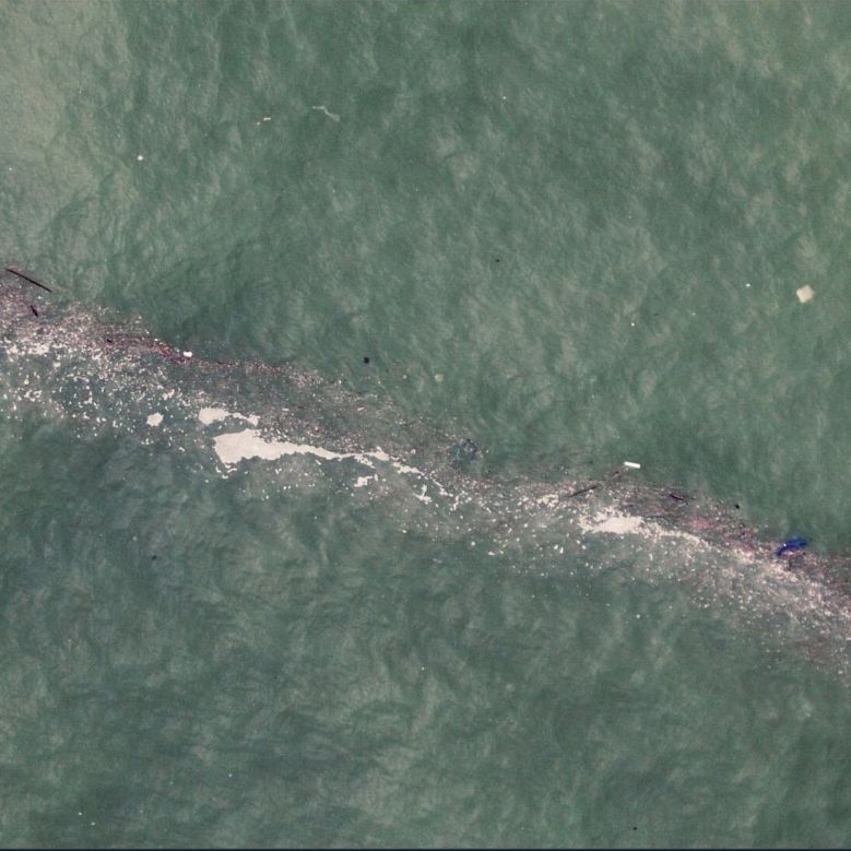
Aerial drone image of a litter windrow in Bay of Biscay, Spain. Windrow width: 1-2 meters. (Credit: ESA)
” data-medium-file=”https://zephyrnet.com/wp-content/uploads/2024/06/mapping-litter-in-the-oceans-from-space-with-existing-satellites.jpg” data-large-file=”https://zephyrnet.com/wp-content/uploads/2024/06/mapping-litter-in-the-oceans-from-space-with-existing-satellites-1.jpg?w=625″ class=”size-medium wp-image-692085″ src=”https://zephyrnet.com/wp-content/uploads/2024/06/mapping-litter-in-the-oceans-from-space-with-existing-satellites.jpg” alt=”Aerial drone image of a litter windrow in Bay of Biscay, Spain. Windrow width: 1-2 meters. (Credit: ESA)” width=”400″ height=”400″ srcset=”https://zephyrnet.com/wp-content/uploads/2024/06/mapping-litter-in-the-oceans-from-space-with-existing-satellites-1.jpg 779w, https://zephyrnet.com/wp-content/uploads/2024/06/mapping-litter-in-the-oceans-from-space-with-existing-satellites-1.jpg?resize=250,250 250w, https://zephyrnet.com/wp-content/uploads/2024/06/mapping-litter-in-the-oceans-from-space-with-existing-satellites-1.jpg?resize=400,400 400w, https://zephyrnet.com/wp-content/uploads/2024/06/mapping-litter-in-the-oceans-from-space-with-existing-satellites-1.jpg?resize=625,625 625w” sizes=”(max-width: 400px) 100vw, 400px”>
Recently ESA published the results of a proof-of-concept study into monitoring marine litter using existing satellites, with promising results for the Mediterranean study area. For the study, six years of historical data from the Sentinel-2 satellite multispectral imaging cameras were used, involving 300,000 images with a resolution of 10 meters. The focus was on litter windrows as common collections of litter like plastic, wood and other types of marine debris that float on the surface, forming clearly visible lines that can be meters wide and many times as long.
These were processed as explained in the open access paper in Nature Communications by [Andrés Cózar] and colleagues. As marine litter (ML) tends to be overwhelmingly composed of plastic, this eases the detection, as any ML that’s visible from space can generally be assumed to be primarily plastic litter. This was combined with the spectral profile of common plastics, so that other types of floating materials (algae, driftwood, seafoam, etc.) could be filtered out, leaving just the litter.
This revealed many of these short-lived litter windrows, with spot confirmation from ships in the area. Some of the windrows were many kilometers in length, with an average of around 1 km.
Although just a PoC, it nevertheless shows that monitoring such plastic debris from space is quite doable, even without dedicated satellites. As every day tons more plastics make their way into the oceans, this provides us with the means to at least keep track of the scope of the problem. Even if resolving it and the associated microplastics problem is still a far-off dream.
- SEO Powered Content & PR Distribution. Get Amplified Today.
- PlatoData.Network Vertical Generative Ai. Empower Yourself. Access Here.
- PlatoAiStream. Web3 Intelligence. Knowledge Amplified. Access Here.
- PlatoESG. Carbon, CleanTech, Energy, Environment, Solar, Waste Management. Access Here.
- PlatoHealth. Biotech and Clinical Trials Intelligence. Access Here.
- Source: https://hackaday.com/2024/06/19/mapping-litter-in-the-oceans-from-space-with-existing-satellites/

